Copernicus Sentinel Data & Philippine EO Ecosystem

CoPhil EO AI/ML Training - Day 1, Session 1

Stylianos Kotsopoulos

EU-Philippines CoPhil Programme

Welcome

Course Introduction

4-Day Advanced Training

  • AI/ML for Earth Observation
  • Philippine EO Professionals
  • Focus: DRR, CCA, NRM
  • Online format

Today’s Goals

  • Understand Copernicus data
  • Explore Philippine EO ecosystem
  • Learn AI/ML fundamentals
  • Hands-on Python and GEE

EU Global Gateway Initiative

  • EU-Philippines space cooperation flagship
  • Building strong partnerships
  • Smart, clean, secure digital links
  • Strengthening health, education, research systems globally

CoPhil Programme Overview

Mission

Support Philippine Space Agency (PhilSA) and DOST to improve use of Earth Observation data for:

  • Disaster Risk Reduction (DRR)
  • Climate Change Adaptation (CCA)
  • Natural Resource Management (NRM)

Key Outputs

  • Copernicus Mirror Site
  • Digital Space Campus
  • Capacity building
  • Pilot services

PhilSA & DOST Partnership

Philippine Space Agency

  • Established 2019
  • Central civilian space agency
  • Space+ Data Dashboard
  • Co-chair of CoPhil

Department of Science and Technology

  • ASTI AI initiatives
  • SkAI-Pinas program
  • National AI investments
  • Co-chair of CoPhil

Session 1 Roadmap

  1. Copernicus Programme Overview
  2. Sentinel-1 Mission (SAR)
  3. Sentinel-2 Mission (Optical)
  4. Data Access Methods
  5. Philippine EO Ecosystem
  6. CoPhil Infrastructure

Duration: 2 hours

Part 1: The Copernicus Programme

What is Copernicus?

Europe’s Eyes on Earth

  • EU flagship Earth Observation program
  • Family of Sentinel satellites
  • Free and open data policy
  • Operational since 2014

“Looking at our planet and its environment for the benefit of all European citizens”

Copernicus Programme Architecture
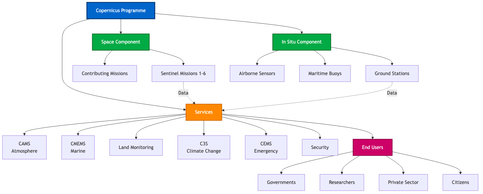
Copernicus Programme Structure showing Space Component, Services, and End Users

The Sentinel Family

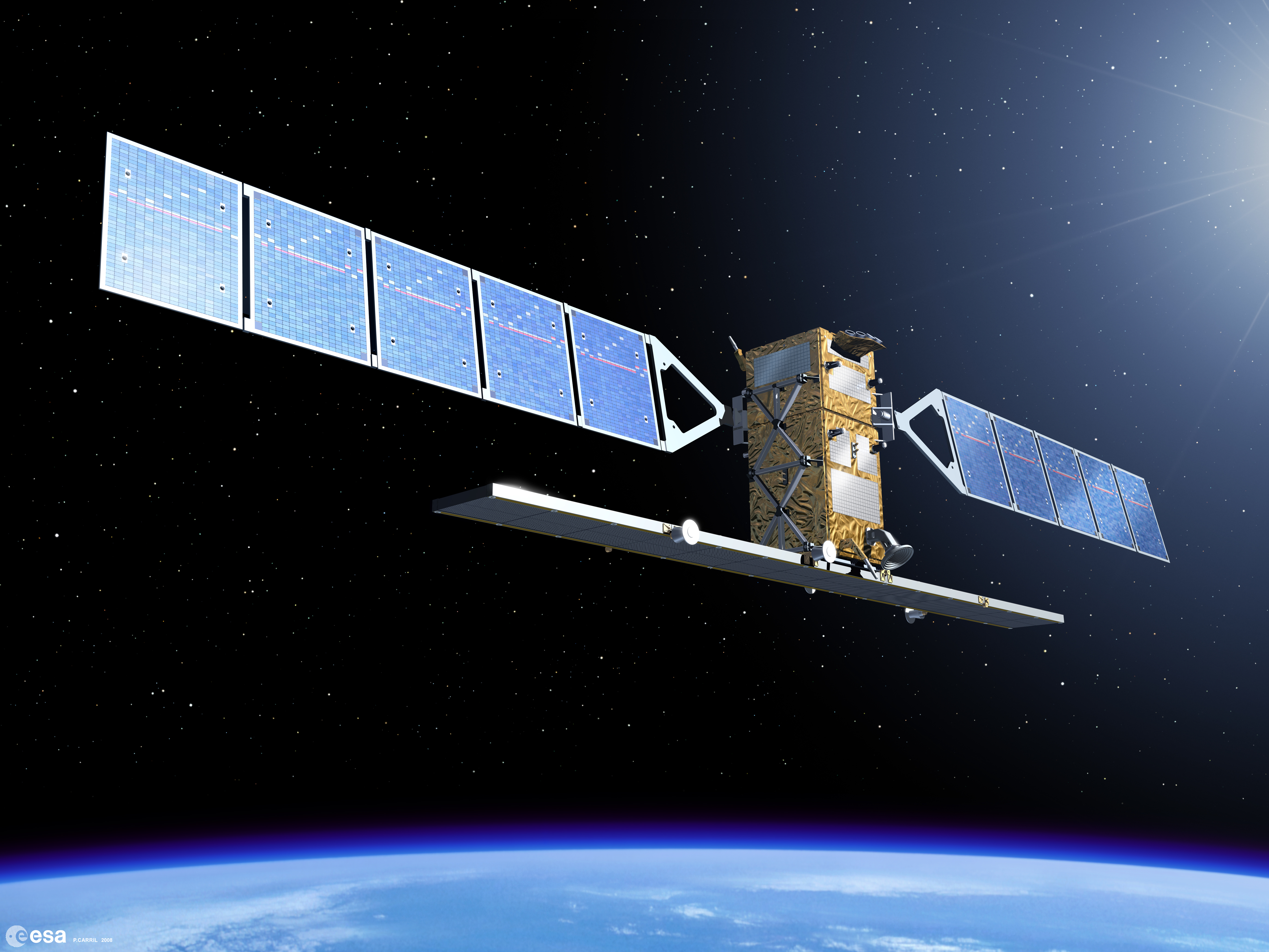
Sentinel-1 (SAR)

  • C-band radar imaging
  • All-weather, day/night
  • 1A operational, 1C launched Dec 2024
  • 6-day repeat (dual constellation)

Sentinel-2 (Optical)

  • Multispectral imaging
  • 13 spectral bands
  • 2A, 2B, 2C operational Jan 2025
  • 5-day repeat (three satellites)

Sentinel-3 (Ocean/Land)

  • Ocean and land monitoring
  • Sea surface temperature
  • Ocean color, vegetation

Sentinel-5P (Atmosphere)

  • Air quality monitoring
  • Atmospheric composition

Copernicus Applications

Emergency Management

  • Flood mapping
  • Fire detection
  • Disaster response

Climate & Environment

  • Deforestation monitoring
  • Agricultural monitoring
  • Water quality assessment

Sentinel-1: SAR Mission

Sentinel-1 Overview

Mission Configuration (2025)

  • Sensor: C-band Synthetic Aperture Radar
  • Satellites: 1A, 1C (operational 2025)
  • Orbit: Polar sun-synchronous
  • All-weather, day/night capability

Key Advantage: Penetrates clouds and works at night

Sentinel-1 Technical Specifications

Parameter Value
Sensor Type C-band SAR (5.405 GHz)
Revisit Time 6-12 days (constellation)
Swath Width 250 km (IW mode)
Spatial Resolution 5m × 20m (IW mode)
Polarization VV + VH or HH + HV
Orbit 693 km altitude

SAR: How It Works

  1. Satellite sends microwave pulses to Earth
  2. Signal reflects from surface
  3. Sensor measures backscatter intensity
  4. Different surfaces = different backscatter

Sentinel-1 Polarization

What is Polarization?

  • Orientation of radar wave
  • VV: Vertical send/receive
  • VH: Vertical send/Horizontal receive
  • HH: Horizontal send/receive

Applications

  • VV: Good for water/flood mapping
  • VH: Sensitive to volume scattering (vegetation)
  • VV/VH Ratio: Discriminates surface types

Backscatter Characteristics by Target

Surface Type Backscatter Appearance Reason
Water (smooth) Very Low Dark/Black Specular reflection
Urban/Buildings Very High Bright White Corner reflectors
Forest/Vegetation Medium-High Gray Volume scattering
Agricultural Fields Medium Light Gray Surface roughness
Bare Soil (dry) Low-Medium Dark Gray Smooth surface
Bare Soil (wet) Medium Medium Gray Increased dielectric

Key Insight: Water appears dark, structures appear bright - the basis for flood mapping!

Sentinel-1 Imaging Modes

Interferometric Wide Swath (IW) - 250 km swath - 5m × 20m resolution - Default over land - Philippine standard mode

Extra Wide Swath (EW) - 400 km swath - 20m × 40m resolution - Maritime/polar regions

Strip Map (SM) - 80 km swath - 5m × 5m resolution - Emergency response - High detail needed

Wave (WV) - Ocean waves - Not used for land

Sentinel-1 Data Products

Level-1 GRD (Ground Range Detected)

  • Multi-looked (reduced speckle)
  • Projected to ground range
  • Most commonly used
  • Faster to process
  • Smaller file size
  • Applications:
    • Change detection
    • Classification
    • Flood mapping
    • Ship detection

Level-1 SLC (Single Look Complex)

  • Preserves phase information
  • Complex-valued pixels
  • Required for InSAR
  • Larger files
  • Applications:
    • Ground deformation
    • Interferometry
    • Coherence analysis
    • Subsidence monitoring

GRD vs SLC - Which to Choose?

Factor GRD SLC
Use Case Most applications Interferometry only
Processing Ready to use Complex processing
File Size ~1 GB ~4 GB
Speckle Reduced Full speckle
Phase Not preserved Preserved
Typical User Most analysts Advanced specialists

For this training and most Philippine applications: Use GRD

Sentinel-1 Pre-Processing “Under the Hood”

What Happens Before You See SAR Data?

For this training, we use pre-processed Sentinel-1 GRD data. Here’s what happens “under the hood”:

S1 Processing Pipeline:

  1. GRD Download → Raw ground-range detected amplitude
  2. Radiometric Calibration → Convert to backscatter coefficient (σ⁰)
  3. Terrain Correction (RTC) → Remove topographic distortions using DEM
  4. Speckle Filtering → Reduce SAR noise (Lee, Refined Lee, or Gamma-MAP filters)
  5. Conversion to dB → γ⁰ (gamma-naught) in decibels for visual interpretation
  6. Tiling/Clipping → Extract area of interest

For Day 3 flood mapping labs: We provide analysis-ready patches with these steps already applied

Sentinel-1 Applications

Flood Mapping
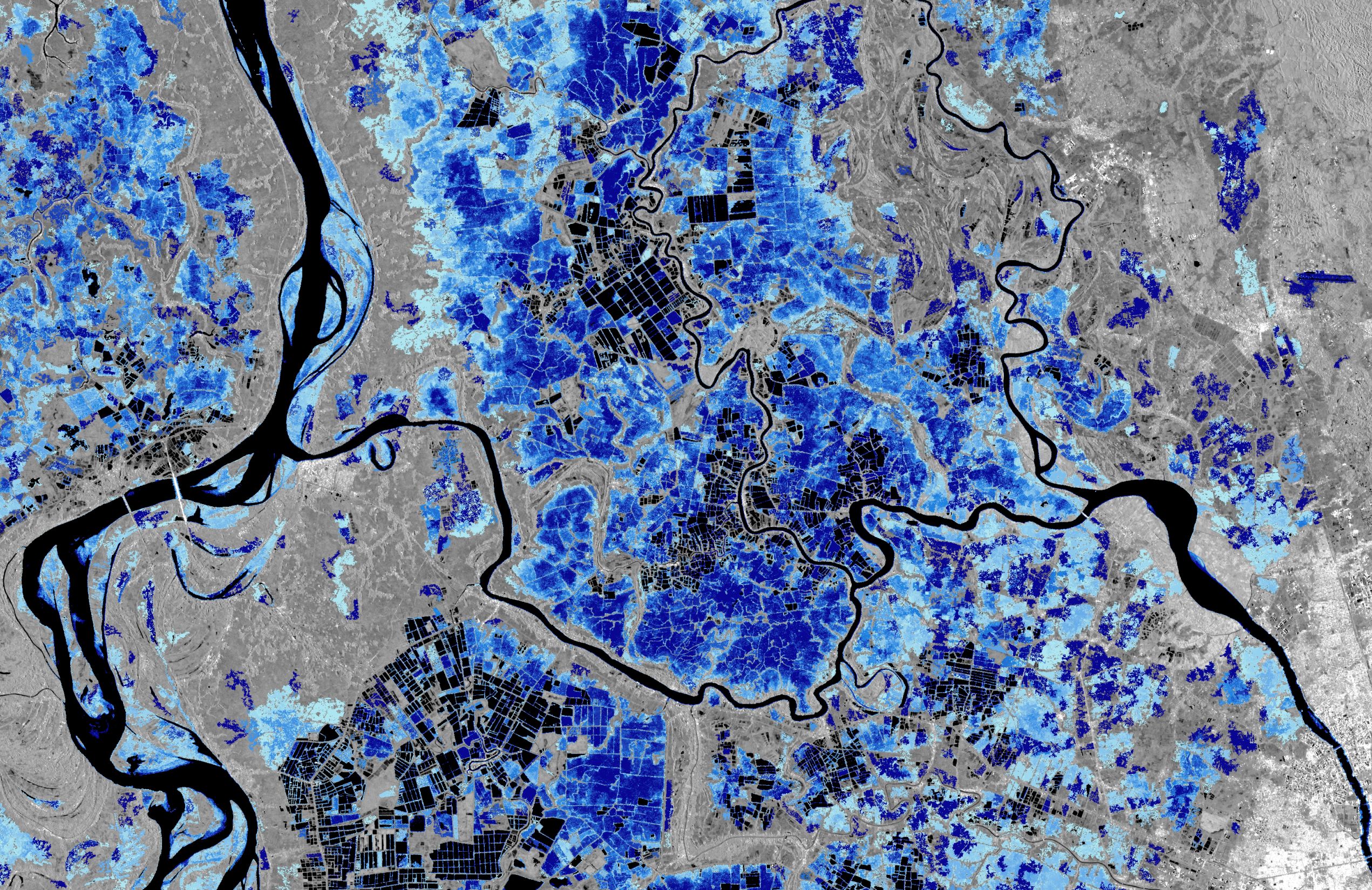
Copernicus Sentinel-1 Flood Monitoring
  • Water appears dark in SAR
  • Works through clouds
  • Near real-time monitoring

Deformation Monitoring
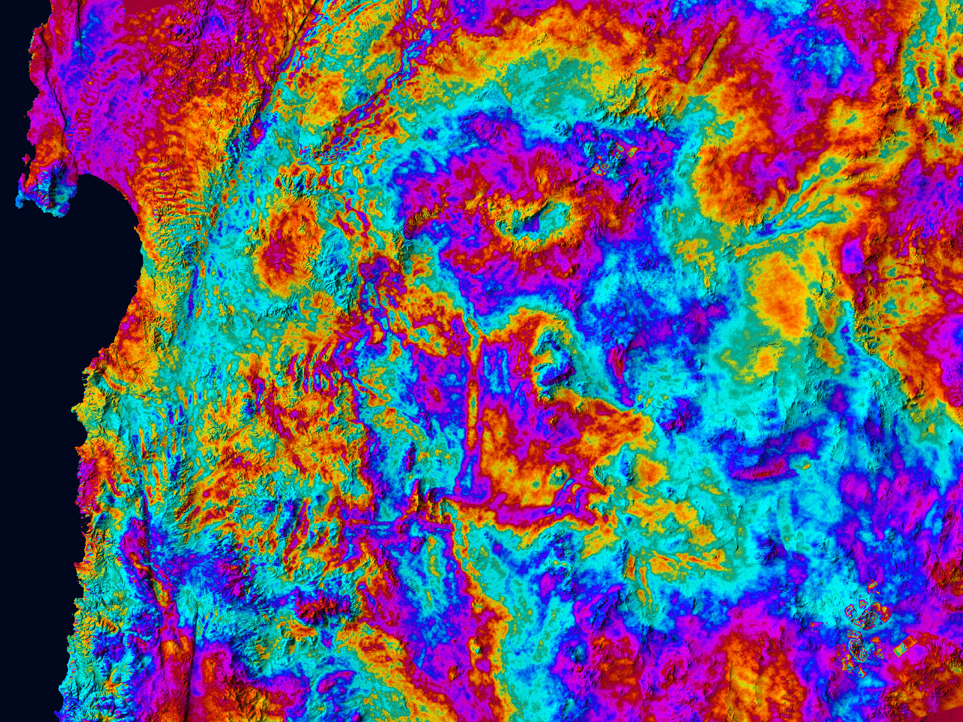
Sentinel-1C Interferogram of Northern Chile
  • InSAR technique
  • Millimeter precision
  • Volcano and earthquake monitoring

Philippine Example: Flood Monitoring

November 2020: Typhoon Ulysses

  • Extensive flooding in Luzon
  • Sentinel-1 detected flood extent
  • Rapid mapping capability

Key Benefits

  • No cloud interference
  • Quick response time
  • Used for rapid damage assessment
  • Supported emergency response

Sentinel-2: Optical Mission

Sentinel-2 Overview

Key Specifications:

  • 13 spectral bands (visible, NIR, SWIR)
  • 10m to 60m spatial resolution
  • 290 km swath width
  • 5-day revisit (three satellites operational 2025)
  • L1C & L2A processing levels

Philippine Example: Mayon Volcano
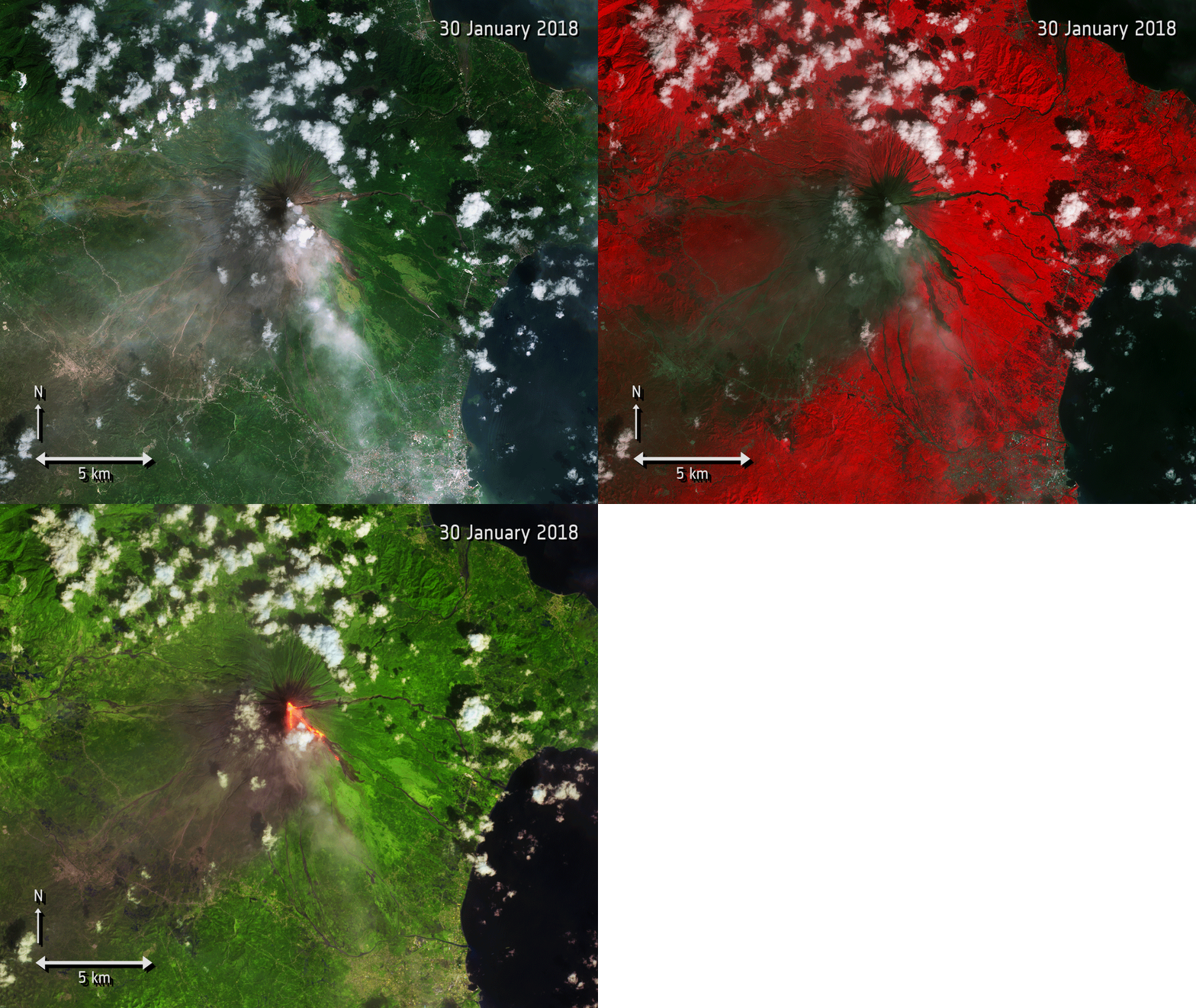
Sentinel-2 monitoring of 2018 eruption

  • False-color composite highlighting lava flows
  • 10m resolution captures detail
  • 5-day revisit enables continuous monitoring

Sentinel-2 Spectral Bands

Band Name Wavelength (nm) Resolution Purpose
B1 Coastal Aerosol 443 60m Aerosol correction, water color
B2 Blue 490 10m Water bodies, atmospheric
B3 Green 560 10m Vegetation health
B4 Red 665 10m Vegetation discrimination
B5 Red Edge 1 705 20m Vegetation stress detection
B6 Red Edge 2 740 20m Vegetation classification
B7 Red Edge 3 783 20m Vegetation stress, chlorophyll
B8 NIR 842 10m Biomass, water bodies
B8A NIR Narrow 865 20m Atmospheric correction
B9 Water Vapor 945 60m Atmospheric correction
B10 SWIR Cirrus 1375 60m Cirrus cloud detection
B11 SWIR 1 1610 20m Moisture content, fire
B12 SWIR 2 2190 20m Moisture, geology, soil

Red Edge Bands - Sentinel-2’s Special Capability

What is Red Edge?

  • Transition zone between red and NIR (700-780nm)
  • Three dedicated bands (B5, B6, B7)
  • Sensitive to chlorophyll content
  • Unique to Sentinel-2 among free satellites

Applications:

  • Early vegetation stress detection
  • Crop health monitoring
  • Forest disease identification
  • Pre-harvest yield estimation

Philippine Use Cases:

  • Rice crop assessment - Monitor crop health and nitrogen status during panicle initiation in Nueva Ecija rice paddies
  • Coconut disease detection - Identify stem bleeding disease and pest infestations through spectral signatures
  • Mangrove health monitoring - Track vegetation stress and recovery in Palawan mangrove forests using red edge indices

Red edge bands detect stress weeks before visible bands show changes

Sentinel-2 Data Products

Level-1C (L1C)

  • Top-of-Atmosphere reflectance
  • Radiometrically corrected
  • Geometrically refined
  • No atmospheric correction
  • Use: If you need raw data for custom processing

Level-2A (L2A)

  • Bottom-of-Atmosphere (surface) reflectance
  • Atmospherically corrected
  • Analysis-ready
  • Scene Classification Layer included
  • Use: For most applications - RECOMMENDED

Always use Level-2A when available - it’s analysis-ready!

Sentinel-2 Band Combinations

True Color (Natural) - RGB: B4-B3-B2 (Red-Green-Blue) - Looks like a photograph - Good for visual inspection

False Color Infrared - RGB: B8-B4-B3 (NIR-Red-Green) - Vegetation appears RED - Classic for vegetation assessment

SWIR Composite (Agriculture) - RGB: B11-B8-B2 - Highlights crop moisture - Soil moisture visible

SWIR-NIR-Red (Burn/Fire) - RGB: B12-B8-B4 - Active fires appear BRIGHT - Burn scars dark purple

Sentinel-1 vs Sentinel-2

Complementary Capabilities

Aspect Sentinel-1 Sentinel-2
Sensor Type Radar (SAR) Optical (MSI)
Weather All-weather Cloud-affected
Time Day & night Daytime only
Resolution 5m × 20m 10m / 20m / 60m
Revisit 6-12 days 5 days
Bands Polarizations (2) Spectral bands (13)
Best For Water, structure, moisture Vegetation, land cover, color

S1 Flood Mapping Tip

VV polarization shows dark water (low backscatter from smooth surfaces)

Best practice: Compare pre-event vs post-event delta for reliability

Synergy: Pair S1 (flood extent through clouds) with S2 (vegetation damage when clear) for complete impact assessment

Synergistic Use Cases

Flood Mapping

  • S1: Detect water extent (through clouds)
  • S2: Assess damage to vegetation/crops (when clear)
  • Combined: Complete flood impact assessment

Forest Monitoring

  • S1: Detect structural changes, biomass
  • S2: Identify tree species, health
  • Combined: Comprehensive forest mapping

☕ 5-Minute Break

Stretch Break

Stand up • Grab water • Back in 5 minutes

Data Access Methods

Platform Choices for This Training

Which Platform for Which Task?

Understanding where to work is crucial - don’t try to train deep models on GEE or download 100GB in Colab!

Task Platform Why Limitations
Data Prep & Exploration Google Earth Engine Petabyte catalog, no download, cloud composites Export limit 32 MB (tile large areas), no deep learning training
ML Training (RF, shallow) GEE or Colab RF works in GEE; small data in Colab GEE memory limits; Colab free tier quotas
Deep Learning (CNN, U-Net) Local GPU / Colab Pro Requires PyTorch/TensorFlow Colab free = limited GPU time; large models need local resources
Large-Scale Processing CoPhil Mirror Site / COARE 400TB local data, HPC resources Requires account; learning curve for APIs
Quick Viz & Download Copernicus Browser Interactive, fast previews Manual selection; bulk downloads tedious

Quotas/Pitfalls to know: - GEE: Memory errors with large computations (tile exports!) - Colab Free: GPU disconnects after inactivity; limited sessions/day - CoPhil/Digital Space Campus: Hosts this training’s materials + local data access

Copernicus Data Space Ecosystem (2025)

New Platform (2023+)

  • Replaced SciHub
  • Modern interface
  • API access
  • Free registration

Features

  • Search by location/date
  • Preview before download
  • Direct download
  • Bulk processing

URL: https://dataspace.copernicus.eu

SentiBoard Dashboard (October 2025)

  • Real-time mission status
  • Data availability insights
  • Acquisition plans
  • Quality metrics
  • Interactive dashboard

Google Earth Engine

Planetary-Scale Platform

  • Petabyte-scale data catalog
  • All Sentinel-1 & Sentinel-2 data
  • Cloud-based processing
  • Free for research/education
  • No download needed!

We’ll use GEE extensively in this training

URL: https://earthengine.google.com

Alternative Data Sources

Alaska Satellite Facility (ASF)

AWS Open Data

  • Sentinel-2 on AWS
  • Cloud-optimized
  • Pay for compute only
  • Programmatic access

Now Available: CoPhil Mirror Site in the Philippines! (Operational 2024-2025)

Part 2: Philippine EO Ecosystem

Overview of Philippine EO Landscape

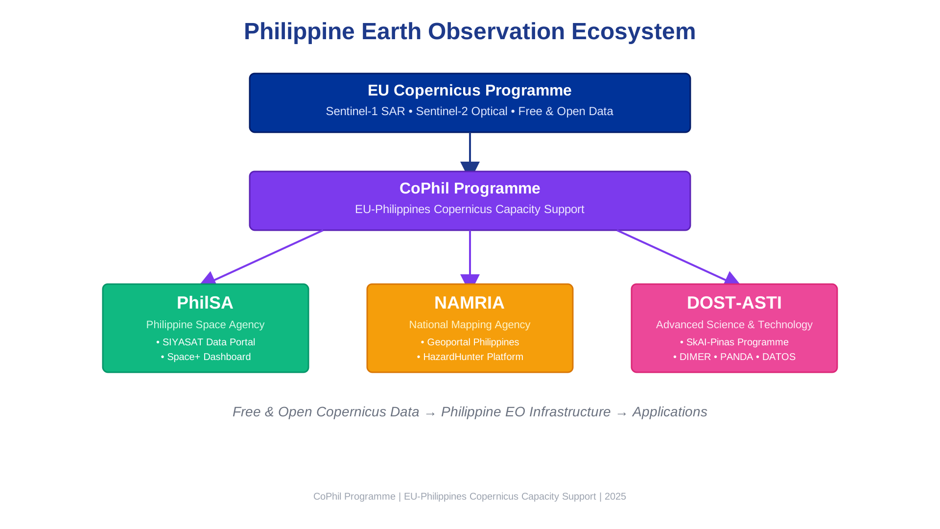
  • PhilSA: Space data and operations
  • NAMRIA: National mapping and geospatial data
  • DOST-ASTI: AI and remote sensing R&D
  • PAGASA: Climate and weather data

Philippine Space Agency (PhilSA)

PhilSA: National Space Agency

Established: August 2019

Mandate:

  • Central civilian space agency
  • Promote space data use
  • Build national capacity
  • Support DRR, CCA, NRM
  • Co-chair CoPhil programme

Website: https://philsa.gov.ph

SIYASAT Data Portal

Purpose (2025)

  • Secure data archive operational
  • Visualization system
  • Data distribution
  • Maritime & terrestrial monitoring

Data Types

  • NovaSAR-1 radar imagery
  • AIS ship tracking data
  • Processed products
  • Analysis-ready data

Space+ Data Dashboard

  • User-friendly web portal
  • Browse satellite imagery
  • Visualization tools
  • Download datasets
  • No programming required
  • Open to government, researchers, public

PhilSA 2025 Initiatives

Space Business Innovation Challenge

  • Empowers Filipino innovators
  • Free satellite data access
  • Build solutions for local needs
  • Earth observation focus
  • Weather & environmental data

Training Programs

  • Downstream data utilization
  • Practical applications
  • Capacity building nationwide
  • Partnership with DOST

COARE Infrastructure

Computing and Archiving Research Environment

  • High-performance computing
  • Data archiving capabilities
  • Science cloud facilities
  • Supports data-intensive research
  • Enables AI/ML workflows

NAMRIA

NAMRIA: National Mapping Authority

National Mapping and Resource Information Authority

Role:

  • Official mapping agency
  • Authoritative geospatial data
  • Topographic maps
  • Hazard maps
  • Land cover datasets

Website: https://www.geoportal.gov.ph

NAMRIA Geoportal

One-Stop Shop for Philippine Geospatial Data

  • National basemaps (1:50,000 scale)
  • Administrative boundaries
  • Topographic maps
  • Thematic maps
  • Downloadable shapefiles and rasters

Land Cover Mapping Project

Latest: 2020 National Land Cover

Classes:

  • Forest types
  • Agriculture
  • Built-up areas
  • Water bodies
  • Wetlands
  • Barren land

Data Formats:

  • Shapefile
  • GeoTIFF
  • CSV
  • GeoJSON
  • KML
  • PNG

Portal: https://land-cover-mapping-project-namria.hub.arcgis.com

HazardHunterPH Portal

Comprehensive Hazard Assessment Platform

Hazard Types:

  • Earthquake-induced hazards
  • Active fault lines
  • Tsunami susceptibility
  • Liquefaction zones
  • Landslide hazards

Applications:

  • Disaster risk assessment
  • Land use planning
  • Infrastructure siting
  • Emergency preparedness

URL: https://hazardhunter.georisk.gov.ph/map

How NAMRIA Complements Sentinel Data

Sentinel Imagery Provides:

  • Current conditions
  • Frequent updates
  • Large-area coverage
  • Multi-temporal analysis

NAMRIA Data Provides:

  • Ground truth for validation
  • Training labels for ML models
  • Historical baselines
  • Official classifications
  • Hazard context

MICRO-EDIT: Using NAMRIA/Space+ as Label Sources

For Day 2 Palawan RF lab: 1. Download NAMRIA land cover shapefile (authoritative classes) 2. Overlay on Sentinel-2 imagery 3. Extract training points per class (forest, agriculture, water, etc.) 4. Train Random Forest classifier 5. Validate predictions against NAMRIA hold-out samples

Space+ Dashboard also provides admin boundaries and infrastructure layers for context in all visualizations.

Example: Use Sentinel-2 to map current land cover, validate against NAMRIA’s official 2020 map, detect changes

DOST-ASTI AI Initiatives

DOST-ASTI Overview

Advanced Science and Technology Institute

  • Lead agency for EO and AI R&D
  • Remote sensing expertise
  • Machine learning development
  • National AI infrastructure
  • P2.6 billion investment until 2028

Website: https://asti.dost.gov.ph

DATOS: Remote Sensing Help Desk

  • Remote Sensing and Data Science Help Desk
  • Rapid analytics during disasters
  • Flood mapping from satellite imagery
  • Damage assessment
  • Crop mapping (rice, sugarcane)
  • Road network detection
  • Supports emergency response agencies

SkAI-Pinas Programme

Philippine Sky AI Program (2021-2028)

  • Flagship AI R&D programme
  • Part of P2.6B DOST AI investment
  • Democratize AI across Philippines
  • Remote sensing & big data focus

Impact (2025)

  • 300+ institutions supported
  • Universities & colleges
  • SMEs & research teams
  • Local government units

DIMER: AI Model Hub

Democratized Intelligent Model Exchange Repository

  • Digital “model store”
  • Pre-trained AI models
  • Ready-to-use
  • Filipino-specific challenges

Available Models

  • Landslide detection
  • Traffic surveys
  • Crop monitoring
  • Land cover classification
  • Flood detection

AIPI: AI Processing Interface

Purpose

  • Streamline large-scale remote sensing tasks
  • Reduce computational barriers
  • Run AI models on ASTI servers
  • Process hundreds of images efficiently

Example: Apply an AI model to 100 Sentinel-2 images over entire region without your laptop

ALaM: Automated Labeling Machine

Challenge

Creating labeled training data is:

  • Time-consuming
  • Expensive
  • Requires expertise
  • Major bottleneck for AI

ALaM Solution

  • Automate labeling process
  • Crowdsourcing capabilities
  • Expert validation
  • Build training datasets

Result: Faster creation of high-quality training data for Filipino contexts

How DOST-ASTI Tools Work Together

  1. ALaM creates training data
  2. Train models and share via DIMER
  3. Process large datasets with AIPI
  4. Deploy for operational use via SkAI-Pinas
  5. Support disaster response through DATOS

PAGASA & Other Data Sources

PAGASA: Weather & Climate Data

Philippine Atmospheric, Geophysical and Astronomical Services Administration

Data Types:

  • Historical rainfall
  • Temperature records
  • Typhoon tracks
  • Climate forecasts
  • Weather observations

Integration: Combine with satellite data for climate analysis

Synergy: Satellite + Ground Data

Satellite Data (Sentinel)

  • Spatial coverage
  • Consistent acquisition
  • Multiple variables
  • Time series

Ground Data (Philippine agencies)

  • Point validation
  • Ground truth
  • Meteorological context
  • Local expertise

Combined = More robust analysis and higher confidence

CoPhil Infrastructure

CoPhil Mirror Site

  • Philippines-based Copernicus data repository
  • Local mirror of Sentinel data
  • Focus on Philippine region
  • Faster access (no international bandwidth)
  • Reliable availability
  • Operational by 2025
  • Hosted by PhilSA with CloudFerro support

Digital Space Campus

Purpose

  • Online learning portal
  • Training materials repository
  • Self-paced learning
  • Community of practice
  • Knowledge sharing

Content

  • Course presentations
  • Jupyter notebooks
  • Datasets
  • Guides & tutorials
  • Forum discussions

Building a Sustainable EO Ecosystem

  1. Data Access: Mirror Site + Data Space Ecosystem
  2. Processing: COARE + AIPI + Google Earth Engine
  3. Models: DIMER repository
  4. Training: Digital Space Campus
  5. Operations: DATOS + Agency integration
  6. Community: SkAI-Pinas network

Result: Complete infrastructure for operational EO AI/ML**

Summary & Integration

Key Takeaways

  1. Copernicus provides free, high-quality satellite data globally
  2. Sentinel-1 (SAR) works day/night, all-weather - essential for tropics
  3. Sentinel-2 (optical) provides rich spectral information - 5 day revisit
  4. Multiple access methods available (Data Space, GEE, Mirror Site)
  5. Philippine agencies provide complementary data and expertise
  6. CoPhil infrastructure supports sustainable capacity building

How It All Connects

Example Workflow: Flood Mapping

  1. Acquire Sentinel-1 SAR data (GEE or Mirror Site)
  2. Validate with PAGASA rainfall data
  3. Process using AI model from DIMER
  4. Scale processing via AIPI
  5. Combine with NAMRIA hazard maps
  6. Deliver to NDRRMC via DATOS

This is what integrated EO capacity looks like!

What’s Next in Day 1?

Session 2 (Next)

  • AI/ML fundamentals
  • Supervised vs unsupervised learning
  • Neural networks basics
  • Data-centric AI
  • → 5-min Concept Check (3 questions)

Sessions 3 & 4

  • Hands-on Python (GeoPandas, Rasterio)
    • Pre-run pip installs to save time
  • Google Earth Engine tutorial
    • Start from ready script, modify filters only
  • Access real Sentinel data
  • SCL cloud/shadow masking (not QA60)

Session Summary

What We Covered:

✅ Copernicus Programme & free/open data policy
✅ Sentinel-1 (SAR) - all-weather monitoring
✅ Sentinel-2 (Optical) - 13 bands, 10m resolution
2025 Updates: 1C & 2C operational
✅ Philippine EO infrastructure (PhilSA, NAMRIA, DOST-ASTI)
✅ Data access platforms (SIYASAT, Geoportal, SkAI-Pinas)

Q&A

Copernicus & Sentinel

  • Mission specifications?
  • Data products & formats?
  • Access methods?
  • Processing levels?

Philippine EO Ecosystem

  • Agency roles & mandates?
  • Data access procedures?
  • Integration with Copernicus?
  • P2.6B AI investment details?

Next: Session 2

Core Concepts of AI/ML for Earth Observation

Coming up after break:

  • What is AI/ML and why for EO?
  • The EO AI/ML workflow
  • Supervised vs unsupervised learning
  • Introduction to deep learning
  • Data-centric AI approaches

See you in Session 2! 🚀

Thank You!

Contact & Resources

European Platforms:
Copernicus Data Space: https://dataspace.copernicus.eu
CoPhil Programme: https://www.cophil.eu

Philippine Platforms:
PhilSA: https://philsa.gov.ph
NAMRIA Geoportal: https://www.geoportal.gov.ph
DOST-ASTI: https://asti.dost.gov.ph

15-minute break before Session 2